The two major weather headlines this year were the record-shattering summer heat and Tropical Storm Harold. We'll get to those shortly, but first, let's see how this year stacked up overall.
Our hottest temperature occurred five times - 103°F on June 21, July 16, and August 15, 16, and 17. Our coldest temperature this year was 32°F on February 11.
The rainiest day was August 22, with just under 4.74" of rain from Tropical Storm Harold. Surprisingly, our windiest day wasn't from Harold or even the wake low on May 8. It occurred earlier in the year on March 2: A strong cold front pushed through the Coastal Bend, and very strong winds swept over the area, prompting a High Wind Warning to be issued for near the hurricane-force winds.


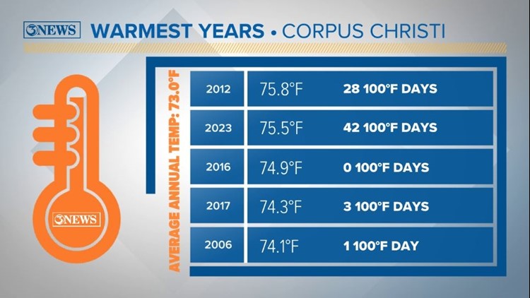
At the end of 2022, we finished with an average temperature of 72.6°F. This year, our average temperature was much warmer at 75.5°F. Our average annual temperature based on 1991-2020 climatology is 73.0°F.
Two months were below-normal and ten months were above-normal in their average monthly temperature. (This includes both highs and lows.)
November was the most below-normal month for 2023. Interestingly, January was the coldest average month but was also the most above-normal. August took the cake yet again for the warmest month on average this year with an average temperature of 88.8°F.
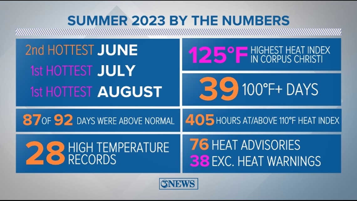
This August was the hottest August on record. More importantly, it also became the hottest month ever for Corpus Christi. July was also the third hottest month on record for Corpus Christi. So congrats, you lived through that and the hottest summer on record.
Keep reading for a breakdown of how individual months stacked up.


This year ended as the second warmest on record, three tenths of a degree behind 2012. Our average annual temperature got an enormous boost from the persistent heat this summer, in addition to the above-normal temperatures at the beginning of the year.
This year, 259 of 365 afternoons experienced above-normal temperatures, 94 afternoons were below-average, and 12 were average. For low temperatures, 213 mornings experienced above-normal temperatures, 123 mornings were below-average, and 29 were average.
The record for the most number of triple digit high temperatures recorded in one year was also shattered. The previous record was 28 days at or above 100 degrees in 2012. This year we recorded 42 days, but 2012 still holds the record for the hottest year.


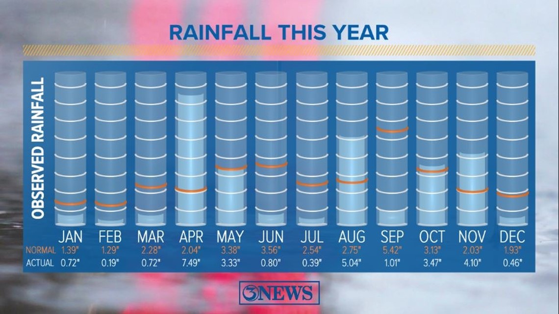
At the end of 2022, Corpus Christi had received 25.83" of rain. This year was a little wetter; we received 27.72". Our average annual total rainfall is 31.74".
At the start of 2023, the western fringes of the area saw drought conditions, which crept in and worsened, covering the Coastal Bend by the end of February. In late March, most of the area was in Severe or Extreme Drought.
Nearly 11" of rain over the course of April and May eliminated the drought, but by the end of June, abnormally dry conditions covered the Coastal Bend once again.
By the middle of August, the entire Coastal Bend was in Moderate, Severe, or Extreme Drought. After Tropical Storm Harold's rains, the central Coastal Bend's drought lightened up, but the edges of the area worsened and Extreme Drought expanded.
Another 7.5" of rain in October and November allowed for drought conditions to recede. Now as we end the year, abnormally dry to Moderate Drought conditions still remain in the northeastern half of the Coastal Bend.
Drought conditions aren't horrible in terms of the soil, but lake levels are running low. On December 31, the combined capacity of Choke Canyon and Lake Corpus Christi was only 30.8%. At 30% Corpus Christi enters Stage 2 Drought Restrictions, something that hasn't happened since 2015.

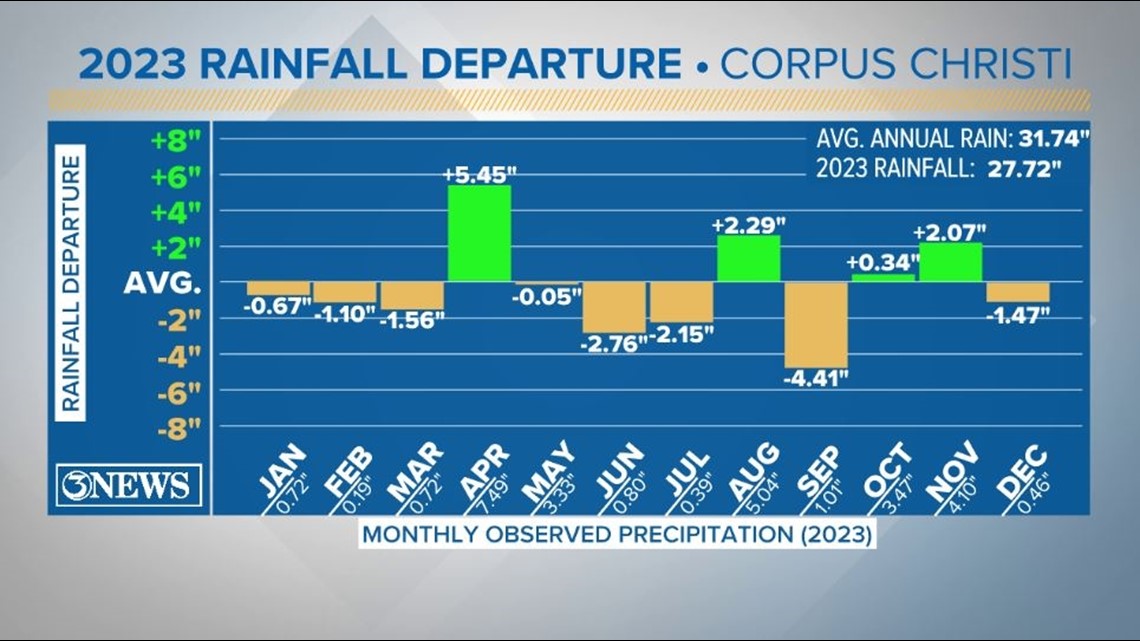
April was our wettest month this year, with nearly 7.50" of rain. I already mentioned the wettest day of the year was August 22 with 4.74" of rain. What I didn't mention was that this rainfall accounted for 90% of August's total rainfall.
Another rainfall stat: 85% of our 2023 rainfall fell within five months - April, May, August, October, and November.

We did make it into the Top 10 for multiple temperature- and rainfall-related records. Most notably, June was the 2nd warmest and July, August, and September were all the 1st warmest on record.
June missed the 1st place spot by a tenth of a degree. Here's some additional thorough breakdowns for June, July, and meteorological summer of this year.
This summer was incredibly hot - I think we can all agree on that. In fact, it was the hottest summer on record for Corpus Christi. Our average temperature from June 1 through August 31 came out to 87.8°F, with an average high temperature of 98.1°F. This was mainly due to the persistent, massive high pressure that spent its time roaming the United States.


Not only was this summer super hot, it was also insanely humid, as evidenced by the 84°F low on August 12.
This year, our temperatures ranged from a high of 103°F to a low of 32°F, a 71°F variation. We hit this high multiple times but only reached the freezing mark once.


Last year, we only had one 100°F+ day (July 10), which broke a 1,058-day streak of no 100°F temperatures. This year was a completely different story.
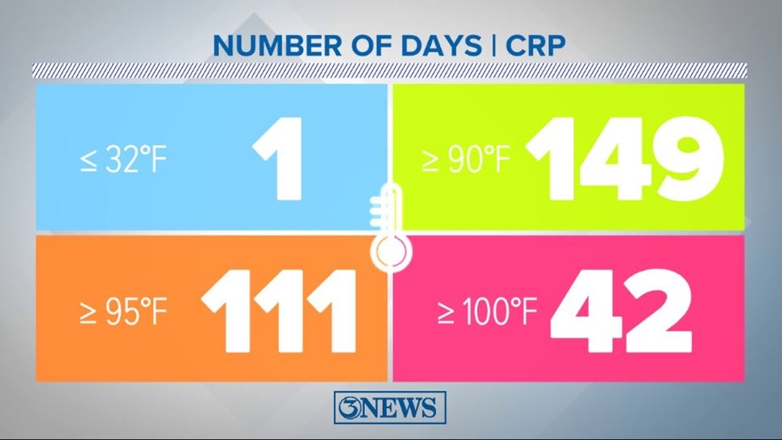
In Corpus Christi - and South Texas in general - it's a known fact that it's hot. Putting numbers to it really emphasizes that, this year even more so. Out of 365 days, this year we reached:
• 32°F or below - 1 day
• 90°F or above - 149 days
• 95°F or above- 111 days
• 100°F or above - 42 days
That means about 41% of the year (approximately 5 months), our high temperature was above 90°F, and 30% of the year (about 3.5 months), our temperatures got to 95°F.
Interesting tidbit: While we reached 100°F+ 42 times this year compared to just once last year, we actually reached 90°F+ fewer times this year (149 days) compared to last year (155 days). Last year tied the record with 2012 (the warmest year on record) for the most days at or above 90°F.

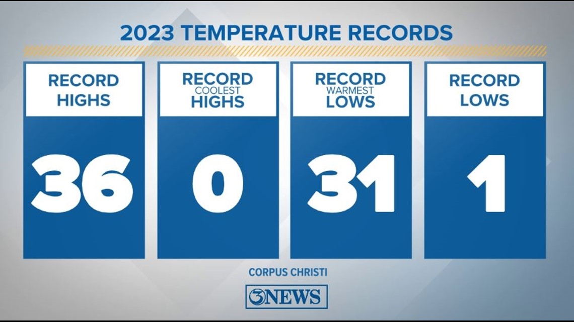
So yeah, it was toasty this year, to say the least. Unsurprisingly, we set lots of temperature records in 2023 - most of those being new record highs and record warm lows.
Of the 36 new high temperature records set this year, 24 of them were for temperatures over 100°F.

Our record breaking wasn't limited to temperatures themselves. We smashed some others, too.
This year, we obliterated the record for most 100°F+ days in a year. The previous record was 28 days, set in 2012. This year, we hit 100°F+ 42 times.
A bit of context: In the last 10 years combined, we've hit 100°F+ 27 times.

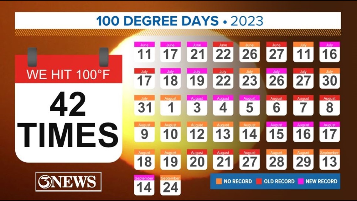
We got to 100°F+ on 6 days in June, 11 days in July, 22 days in August, and 3 days in September. This means we doubled June's record, almost quadrupled July's record, and nearly doubled August's record.
By temperature, this year we reached:
• 103°F - 5 days
• 102°F - 3 days
• 101°F- 14 days
• 100°F - 20 days


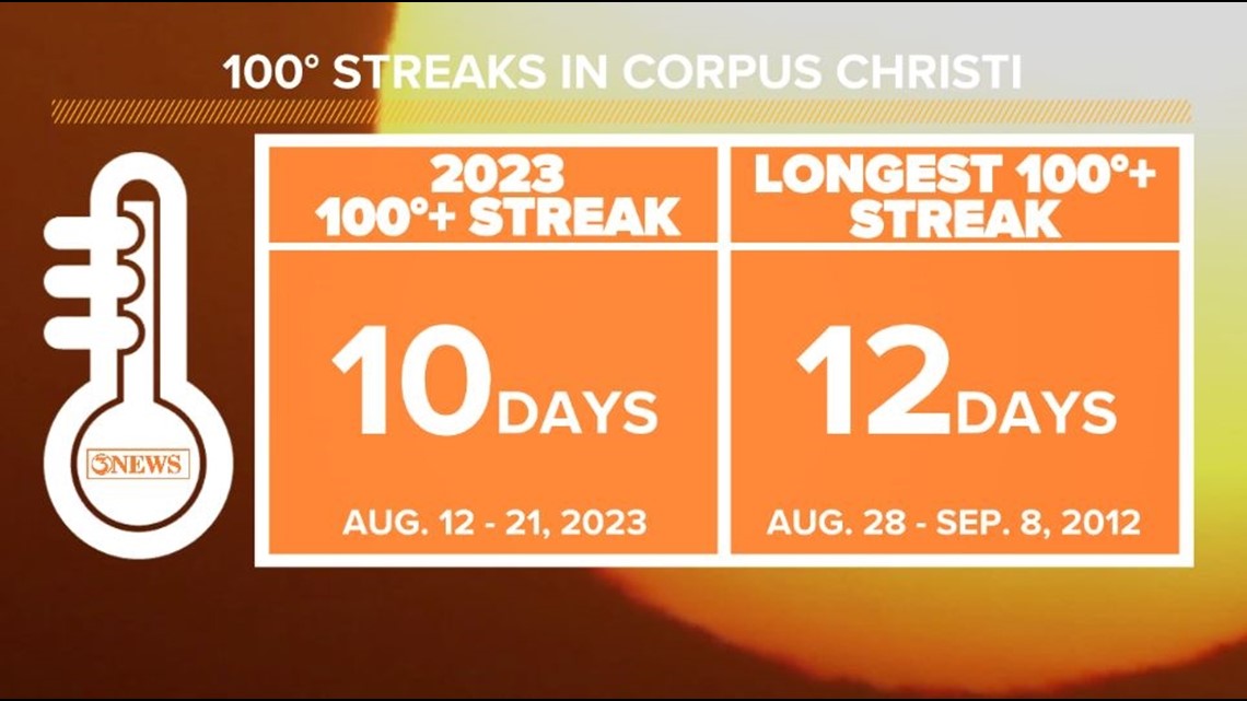
We didn't quite set the record for the longest 100°F+ streak, but we got close - twice. The longest streak held as August 28 through September 8, 2012 (12 days).
This August, we had a second-place worthy streak of 10 days (August 12-21) and a third place streak of 8 days (August 3-10). August 11 topped out at 99°F, breaking what could have been a 19-day run at or above 100°F.

And while the air temperatures were plenty hot, the heat index is honestly what actually matters in the summer.
Not only is the heat index the temperature that our bodies react to, it's the qualification for heat-related advisories and warnings. We had plenty of both this year.
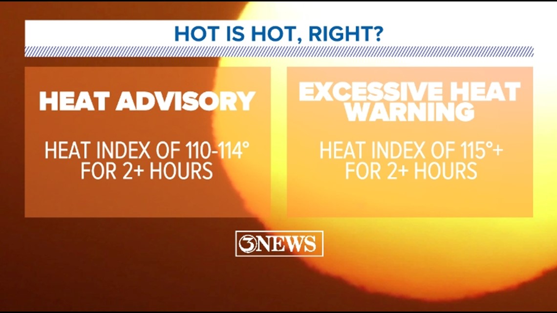
Heat Advisories are issued when the forecast calls for heat indices of 110-114°F for two or more hours.
Excessive Heat Warnings are a step above, issued when the heat index is expected to be 115°F+ for two or more hours.
Our first Heat Advisory was issued June 9 and the last was issued September 24. In total, we had 87 Heat Advisories this year. (Note: the Heat Advisory on July 29 was cancelled, but is still being counted here.)
From July 8 through August 21, we saw 45 consecutive Heat Advisories.

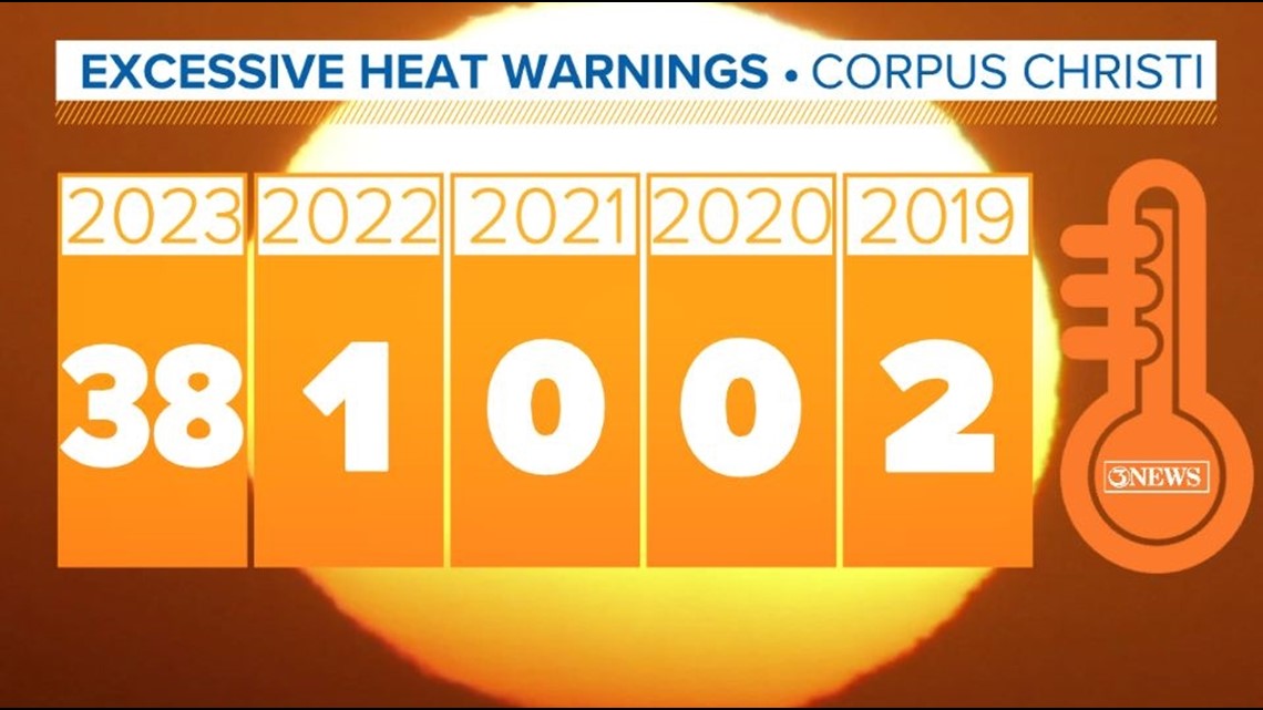
Our first Excessive Heat Warning was issued June 13/15 (Coastal Bend/Corpus Christi) and the last was issued August 14.
In the past five years, we've had a total of three Excessive Heat Warnings (including zero in 2018).
From June 15 through August 14 of this year, 38 Excessive Heat Warnings were issued for Corpus Christi. Around the Coastal Bend, inland areas saw Excessive Heat Warnings issued as early as June 13, with a total of 41 warnings being issued by the end of the year.

I mentioned this summer's humidity earlier. That is what combined with already hot afternoons to produce the extremely dangerous heat indices.
While June 2023 missed the top slot for hottest June on record, it actually felt about 10°F hotter than the hottest June on record (2013) because of the tremendous amount of humidity.
Another all-time record we busted this year was the highest heat index ever recorded in Corpus Christi (unofficially). We actually set and re-set the this a couple times over the summer. The record now stands at 125°F, set June 17 - and that wasn't even the highest one observed around the Coastal Bend.
Here's another mind-blowing statistic: Over the course of this summer, we spent 405 hours with a heat index at or above 110°F. The next most record was 72 hours in 2019.

But where's the fun in leaving the record at that?
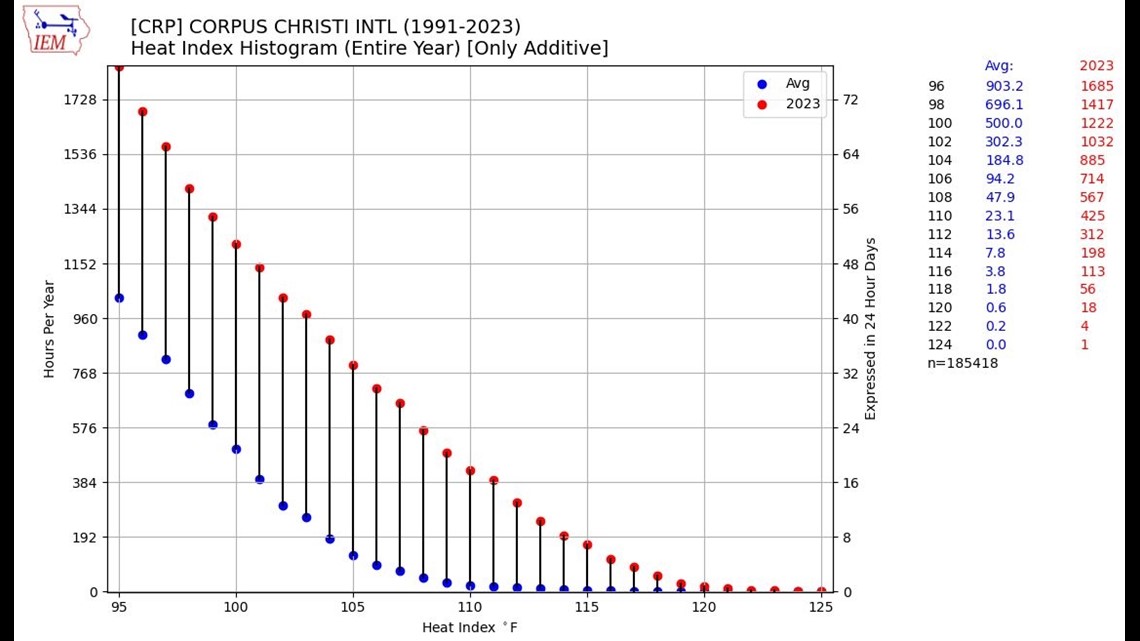
By the end of 2023, we spent 425 hours with a heat index of at least 110°F. You can see in the graph below we spend on average 23 hours with a heat index of 110°F+ per year.
(This graph shows the difference between the average amount of time spent at a certain heat index over the course of a year compared [blue] to what actually occurred in 2023 [red].)
This year, 91 of 365 days experienced a heat index of at least 110°F at some point.

Enough of the heat. Let's move on to Tropical Storm Harold.
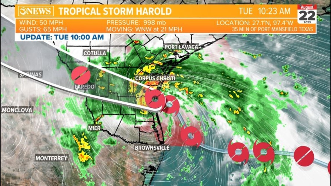
Initially dubbed "Potential Tropical Cyclone Nine" on August 21, Tropical Storm Harold was named at 1:00am August 22 - less than 9 hours before landfall.
Harold made landfall as a 50 mph tropical storm on Padre Island in northern Kenedy County at 9:50am on August 22. This was the first named storm to make landfall in Texas since Hurricane Nicholas in September 2021.
Peak wind gusts topped out at 67 mph on Loyola Beach in Kleberg County. Corpus Christi recorded a 48 mph sustained wind and a 59 mph wind gust.


Hours before landfall, the center of Harold reformed and jumped northward, forcing the National Hurricane Center to adjust their forecast cone.
Sometimes when a weak tropical system is in the process of strengthening and there's not yet a well-defined eye, the center of a developing storm can jump around. (This also happened several times with Nicholas.)
Harold ended up making landfall 50 miles south of Corpus Christi and 35 miles north of Port Mansfield, where it was expected to make landfall before the center jumped northward.

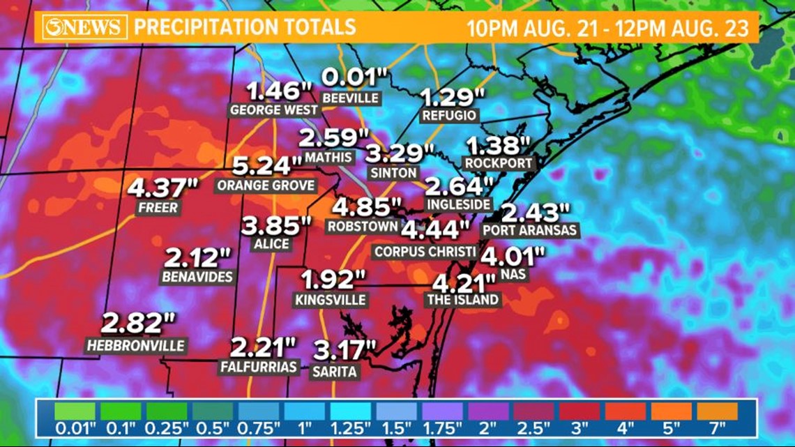
The path of Harold brought some much-needed rain to the Coastal Bend and to both watersheds. Most locations picked up two to four inches of rainfall. The highest reported rainfall from Tropical Storm Harold was 6.11" in Calallen.
Corpus Christi International Airport picked up 4.74" of rain, setting the August 22 daily rainfall record. This broke the previous record of 4.56", set in 1999 when Hurricane Bret hit Kenedy County in a similar spot.
Click here to view a post from Meteorologist Kristin Walla that shows rainfall for all reporting locations around the Coastal Bend.

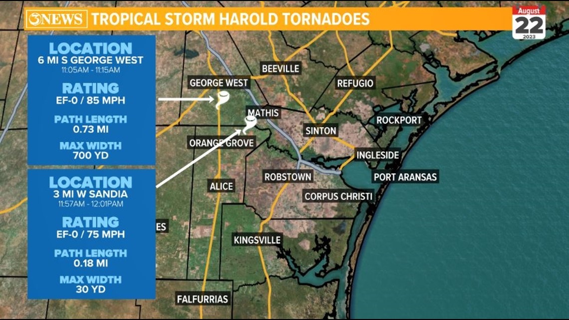
While we all received beneficial rainfall, some folks around the Coastal Bend had to deal with tornadoes, which typically spin up in the outer bands of a tropical storm. We had multiple tornado warnings but only two confirmed tornadoes.
The first touched down south of George West. The second confirmed tornado touched down west of Sandia, or north of Orange Grove. Both tornadoes were given an EF-0 rating.

Hopefully as we've shifted into an El Nino weather pattern, it will bring a cooler and wetter winter to the Coastal Bend as the Pacific jet stream brings us more moisture. I know I'm ready for it.
Let's not repeat this summer...