
CORPUS CHRISTI, Texas — August 19 9:30 p.m.
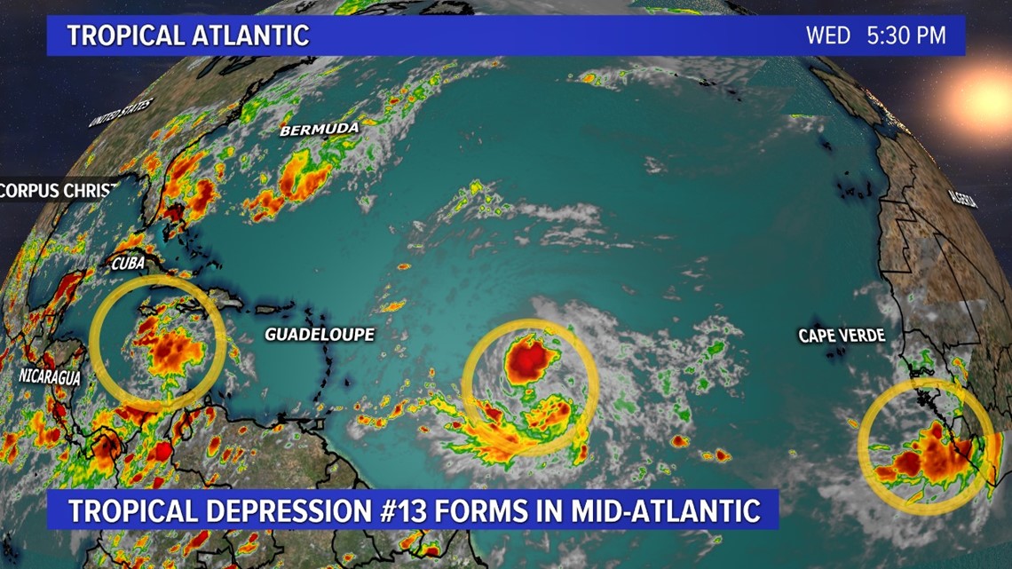
Tropical Depression #13 has formed in the mid-Atlantic.

August 19 4:24 P.M.
Severe thunderstorm warning in effect for a storm over Gregory/Portland until 5:00 p.m. Hazards are quarter sized hail, 60 mph wind, lightning, and heavy rain. Storm is moving SW at 10 mph.
August 19 8:50 a.m.
We've been following these two tropical waves all week (now 3 with another tropical wave coming off of Africa). As of Wednesday morning, it's looking like the one we've got to watch a little more closely in the Coastal Bend is Invest 97L, currently in the Caribbean Sea.
Watch the live question and answer session here:
Invest 97L is forecast to continue to move west and interact with the Yucatan Peninsula this weekend. We'll need to pay extremely close attention to how this system interacts with the Yucatan and then re-emerges in the western Gulf next week.

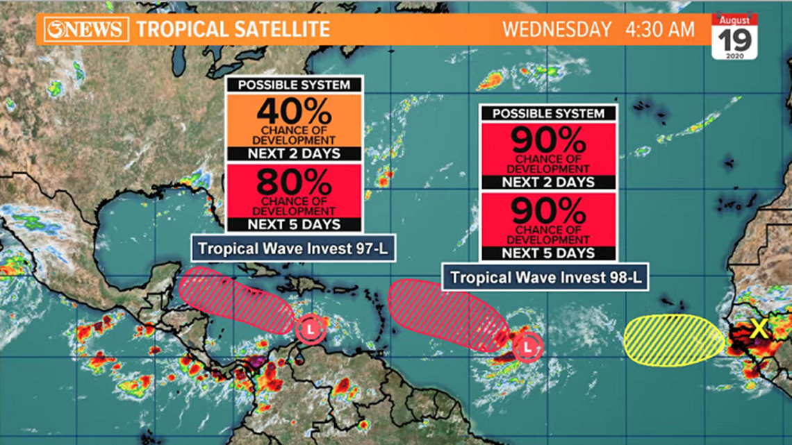
Forecast guidance isn't overly aggressive on the development of Invest 97L and a lot of it's future will depend on its status prior to the Yucatan. When tropical systems have developed prior to interacting with land, they often have difficulty re-organizing after moving back over water, in the short term. When tropical systems are undeveloped and interact with land, development is easier when moving back over water. This isn't always the case, but it's something I've noticed and will be paying close attention to.
Often, the Harvey comparisons creep in when storms are in this position. Remember, ALL STORMS ARE DIFFERENT in how they develop and move as the atmosphere isn't always the same for every storm...thus, forecast difficulties. If all storms were the same, forecasting would be easy and I wouldn't have a job. I chuckle a bit in my head when I see the Harvey comparison commentary. Fun Fact: ALL storms that make it to the Coastal Bend have to work through the Caribbean or Gulf of Mexico...


So, to say this looks similar to Harvey is true, but it's just a look, not the same storm/forecast. Think of it this way: I-37 is the main corridor to get to San Antonio, right? Well, if there was a bad accident on that route on your way there one time, does it mean that there will be one every time? No. Didn't mean to break off on that much of a tangent, back on track...


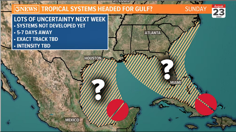
The custom map above shows the uncertainty associated with the two tropical waves and where they be located on Sunday. With respect to Invest 97, as of this morning, the most plausible solution, given the data at hand, is that this stays a relatively weak system and moves into the Western Gulf next Monday/Tuesday, moving in to land somewhere in Texas or Mexico Tuesday or Wednesday. Because this feature has not developed AND it is still 5-7 days away from MAYBE moving in somewhere in the Western Gulf, there's still HIGH uncertainty with the forecast. Exact track/intensity are all up in the air.
Invest 98L has a higher probability to develop and looks more impressive this morning. It'll likely be the stronger of the two, but it will move along the northern fringe or just north of the Caribbean through the weekend and early next week. This will then bend north, toward the Eastern Gulf or Southeast Atlantic.
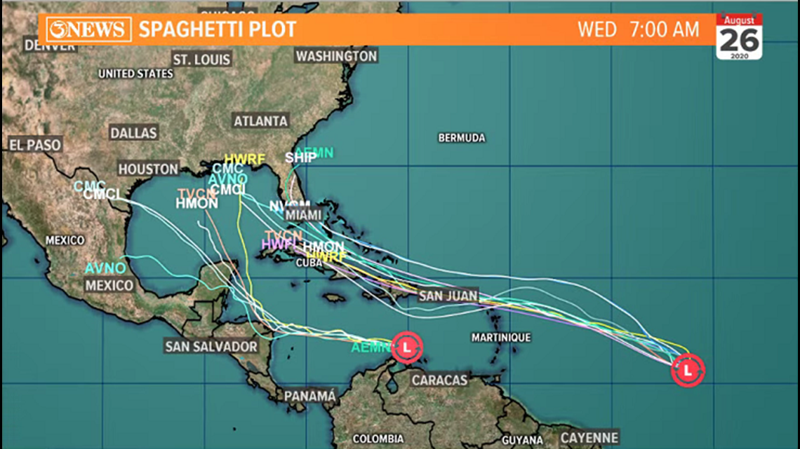
Spaghetti Plot on these two features shows the wide spread on Invest 97 and the north turn toward Florida on Invest 98.

Keep up to date with current forecasts on these systems and find a source you can rust and depend on. The forecast will change in the coming days as more data becomes available and these features develop further.
-Holt, out.